
This week the ADS would like to highlight the Geoarchaeological Borehole Evaluation at Jubilee Gardens.
Background of the Project
The Avon Valley is home to some of the most significant Palaeolithic archaeological records in Britain. This area forms part of the 80km route through Southern England used by both hominins and animals during the Pleistocene, which continued with the beginning of the Holocene, and evidence of use from Mesolithic to modern age have been found within the valley.
In March 2022 as part of the A31 Ringwood Improvement Scheme , two geoarchaeological boreholes were drilled within the Avon Valley at the site of Jubilee Gardens, Ringwood, Hampshire. This work was carried out with the intention to determine their potential for characterising environmental change and providing context for archaeological remains in the vicinity of the site.
Alongside the boreholes samples, local geotechnical records were used to produce deposit models. These were further refined following the results of the palaeoenvironmental assessment – including those of pollen, diatoms, ostracods, macroplant remains, and radiocarbon dates obtained from the Holocene sequence.
Reconstructing the Landscape
The study was able to reconstruct the landscape of Jubilee Gardens from the Pleistocene to the Victorian and Modern eras of use.
During the Holocene, pollen evidence shows that the local environment was varied. Wetlands were dominated with grasses, sedges, and reeds, while nearby woodland covered the valley floor and floodplain, mainly made up of alder, willow, and hazel trees. This mixture of wetland and woodland would have provided a rich environment for early communities, offering access to natural resources and settlement. However, no direct evidence of settlement activity survives.
Organic material dating to the Neolithic period is covered by a layer of silty sediment. This increase in mineral-rich material was partly caused by rising sea levels, which affected waterways across the region. It may also reflect greater soil erosion caused by human activities such as woodland clearance and early farming, which could have increased runoff and sediment being deposited in the area.
In the Early Medieval period, alder and willow trees were still present at the site, although significantly reduced in quantity. Pollen from the surrounding landscape suggests a more open environment used for farming. Evidence of cereal crops such as wheat and barley was found, along with small amounts of rye and hemp or hop, which are commonly found in Saxon and medieval pollen records.
Historic Ordnance Survey maps help show how the landscape changed more recently due to landscape conditions and human impact. Maps from the 1840s–1880s show the site located along the southern edge of a water meadow during the Victorian period. Later maps from 1937–1961 reveal larger changes with the A31 being built, more housing appeared, and the water meadow was replaced by several smaller channels.
Combined, this evidence highlights long-term human activity in the Avon Valley, while highlighting the importance of identifying palaeoenvironmental remains in the region in order to enhance the understanding of such important sites.
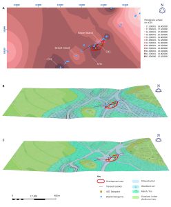
Topographic models. A) Early Holocene surface elevation. B) Early Neolithic schematic landscape reconstruction. C) Early medieval schematic landscape reconstruction. Image credit: AOC Archaeology.
The Archive
This collection comprises images, reports, and spreadsheets from a geoarchaeological borehole evaluation and the subsequent palaeoenvironmental assessment at the site of Jubilee Gardens.
The downloads section of the archive include:
- OASIS Reports
- Pollen Analysis
- Results of palaeoenvironmental assessment
- Field Images
- Deposit Model Datasets
Internet Archaeology
This collection is related to an open access article published in Internet Archaeology.
Taylor, J., Langdon, C.T., Scaife, R. and Cameron, N.G. 2025 The River That Swallowed the Ringwood Prehistoric Landscape: Geoarchaeological investigations in advance of the development of the A31, Hampshire, England, Internet Archaeology 69. https://doi.org/10.11141/ia.69.6
Latest News & Events
See all

Virtual Research Environments Launch
The Heritage Science Data Service (HSDS) is thrilled to announce the official launch of...

Upcoming Events
We are excited to share that HSDS will be attending a number of conferences...

HSDS Training Hub
The HSDS is thrilled to announce we recently launched our new training hub, a...